
|
Boat House FarmTuesday, 1st July 2003, Page 2 of 2, West Yorkshire |
![]()
![]()
![]()
![]() Rocks | History |
Workshop |
Links | Home
Page
Rocks | History |
Workshop |
Links | Home
Page
![]()
 By
the canal at British Oak a digger-mounted drill is being used to demolish
one of our last local monuments to the coal industry: an uninspiring concrete
coal staithe from which the last load of coal to be transported on this
canal was tipped from railway hopper-trucks to a waiting barge below in
the early 1980s.
By
the canal at British Oak a digger-mounted drill is being used to demolish
one of our last local monuments to the coal industry: an uninspiring concrete
coal staithe from which the last load of coal to be transported on this
canal was tipped from railway hopper-trucks to a waiting barge below in
the early 1980s.
The coal was transported five miles up the Calder and Hebble Navigation to Ravensthorpe power station which itself was demolished some 15 or 20 years ago.
 An
even older monument - if you can use that term for a vernacular building
- has just disappeared: the stone-built, flag-roofed barn (perhaps it
was originally a farmhouse) of Boat House Farm, south
of the river opposite Millfield Lagoons, Thornes.
An
even older monument - if you can use that term for a vernacular building
- has just disappeared: the stone-built, flag-roofed barn (perhaps it
was originally a farmhouse) of Boat House Farm, south
of the river opposite Millfield Lagoons, Thornes.
The Map of 1841
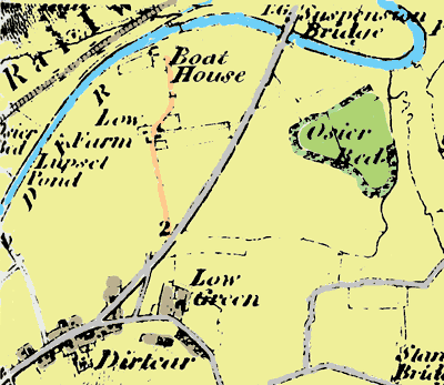 'Boat
House' is marked on the first Ordnance Survey map of the area, published
in 1841, upstream from the suspension bridge, which at that time had been
fairly recently built for the Denby Dale Road turnpike,
which runs from top to bottom of the map. I guess that this bridge probably
put the small ferry boat out of business.
'Boat
House' is marked on the first Ordnance Survey map of the area, published
in 1841, upstream from the suspension bridge, which at that time had been
fairly recently built for the Denby Dale Road turnpike,
which runs from top to bottom of the map. I guess that this bridge probably
put the small ferry boat out of business.
The suspension bridge later collapsed under the weight of a hay wagon, so that must have brought a bit of trade back to the ferry!
Osier beds near the river provided crops of willow branches for basket and hurdle making.
A narrow lane or path running south from Boat House to Low Green continues to be used as a public footpath and still has hedgerow shrubs alongside it giving some sense that it is an ancient lane. At least it was still a footpath when I last walked along it a year or more ago: there's been continued development of the river terraces for offices and so on since then. River terraces can be a rich ground for archaeology but I haven't heard of any fieldwork being done here prior to the developments. If there were any excavations I'd be interested to hear what turned up.
Dane Stakes
'Dirtcar' changed it's name to Durker in the twentieth century, as did our own parish of Sitlington, further up the valley: it used to be called Shitlington.
A mystery: the 'Dane stakes', not marked on this map, were in this area. They're referred to in the diaries of Clara Clarkson. What they were, I've yet to find out.
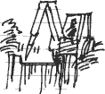
I
never drew Boat House farm and now I won't get the chance, it's gone,
but at least I drew the coal staith while it was still in use. In fact
I had a lift back along the canal to Horbury on the last coal barge after
it had been unloaded by crane at Ravensthorpe power station.
![]()
![]() Next page | Previous page |
This day in
2001 | This month |
Nature Diary |
Home
Page
Next page | Previous page |
This day in
2001 | This month |
Nature Diary |
Home
Page
![]()