Richard Bell's Wild West Yorkshire nature diary
Field Walking
‹previous
| this month | home
page | e-mail me | next›
Wednesday, 17th January, 2007
 On
the day last month when my friend Martin and I tested out my four Walks
around Horbury I got new insight into the way Horbury's St Peter's
church relates to the landscape. Every couple of hours, after walking
another 3 or 4 mile circuit we found ourselves returning to the church from
a different direction. We'd go down into the valley or off towards the next
ridge then wind back into the town through the old streets and ginnels. Ginnel
is the usual word for a footpath between houses in this part of the world. Sometimes
they're 'snickets'.
On
the day last month when my friend Martin and I tested out my four Walks
around Horbury I got new insight into the way Horbury's St Peter's
church relates to the landscape. Every couple of hours, after walking
another 3 or 4 mile circuit we found ourselves returning to the church from
a different direction. We'd go down into the valley or off towards the next
ridge then wind back into the town through the old streets and ginnels. Ginnel
is the usual word for a footpath between houses in this part of the world. Sometimes
they're 'snickets'.
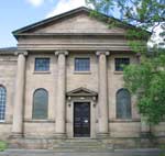
The 18th century church is a striking classical design by John Carr
(1723-1807). Horbury has plenty of attractive old houses and pubs, a few
dating back to medieval times but for visual impact the church is unrivalled.
On our rounds that day it was the still centre and the rest of the built environment
went by in a bit of a blur.
I can't help thinking of it as the Georgian equivalent of a space shuttle.
It stands on a much older site; saxon burials have been found nearby.
Time Team
 'You're
so sceptically agnostic that you're almost atheist,' said presenter Tony
Robinson to Professor Mick Aston (right),
on Sunday's edition of Channel 4's Time Team, 'yet you've spent your
life excavating sites like this.'
'You're
so sceptically agnostic that you're almost atheist,' said presenter Tony
Robinson to Professor Mick Aston (right),
on Sunday's edition of Channel 4's Time Team, 'yet you've spent your
life excavating sites like this.'
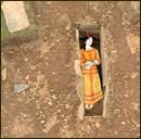
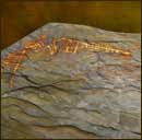
They were excavating a keeill (a small chapel) on the Isle of Mann. The six
burials that the team uncovered included 'the stunningly well-preserved remains
of a woman, including a knot of plaited hair' dating from c. 590 AD (reconstruction
by Victor Ambrus, left) and a stone inscribed with Ogham script (below,
right). Ogham experts identified it as 11th-century Gaelic and translated
references to 'corner', '50' and 'group', 'gang', 'throng' or possibly 'throng
of warriors'.
 Aston
replied that he is drawn by the energy and activity that always surround religious
sites, even though, he admits, he doesn't understand the impulse that led to
them being there.
Aston
replied that he is drawn by the energy and activity that always surround religious
sites, even though, he admits, he doesn't understand the impulse that led to
them being there.
Despite all the high tech gadgets and the teams of excavators, the programme
regularly emphasises that to understand an archaeological site you need to walk
the country around it. The keeill, for instance, stood inside the circular ditch
of a much earlier Bronze-age site which would have been a prominent ridge-top
landmark in its time. In today's often cluttered landscapes it's sometimes difficult
to spot the way a site fits into its surroundings.
The photographs are from the Time
Team website.
Memory-Map
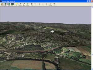 Here's
St Peter's church, marked by the white cross, on its hill top setting at the
centre of Horbury, as seen on Memory-Map.
Here's
St Peter's church, marked by the white cross, on its hill top setting at the
centre of Horbury, as seen on Memory-Map.
Memory-Map is a programme for planning walks and cycle routes. My friend David
Stubbs, one half of a Solway
Dory canoe building team, uses it to plan canoeing expeditions on the west
coast of Scotland.
The version that I've gone for includes Getmapping aerial
photographs which makes it a unique way to get to know the lie of the land.
It's easy to adjust the vertical scale, as I have here, and change the lighting
to emphasise particular features.
My CD of the 1:25,000 Ordnance Survey map for West Yorkshire arrived today.
With this version, you can specify your own selection of up to 2,500 km from
the OS Explorer map, which neatly covers the county.
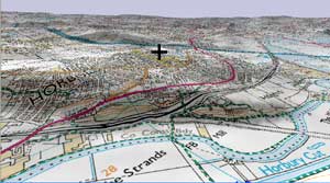 You
can display the map itself as 3D model of the landscape then swivel around,
change view point and zoom in and out to spot features and relationships that
you wouldn't easily see on a regular map.
You
can display the map itself as 3D model of the landscape then swivel around,
change view point and zoom in and out to spot features and relationships that
you wouldn't easily see on a regular map.
I remember occasionally making 3D contour maps out of cardboard or expanded
polystyrene ceiling tiles to give myself a feel for an area I was exploring.
This is so much more versatile and accurate: I feel that it's what computers
were made for.
You can mark a route on the map then switch to 3D to see a fly-through of it.
'Watch out!' warns the manual, 'If you suffer from motion sickness, you might
need one of those bags from the seat pocket in front of you!
Link: Memory-Map
‹previous
| this month | home
page | e-mail me | next›