
 I
HAVEN’T SEEN the Strands, the marshy field between the
river and the canal, so waterlogged for years.
I
HAVEN’T SEEN the Strands, the marshy field between the
river and the canal, so waterlogged for years.Richard Bell's Wild West Yorkshire nature diary
Saturday, 20th January, 2007
I
HAVEN’T SEEN the Strands, the marshy field between the
river and the canal, so waterlogged for years.
There are no ducks to be seen, just one moorhen paddling
about amongst the clumps of rushes and 18 pied wagtails trotting
about at the edge of the flood.
Surprisingly though, along with the resident pair of mute swans,
there are no fewer than 120 Canada geese on the canal, on a
100 yard stretch between willow trees. We guess that they’ve congregated
here to find some shelter from the cold north-westerly wind but they might have
been attracted by the fresh green shoots of winter wheat in the adjacent field.
There’s a strandline of twiggy debris strewn in swags across the towpath, the result of the high water level in the canal and those strong winds we’ve had.
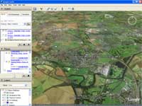 On
Wednesday, I was writing about the aerial view of Horbury across
the valley and a reader in the Netherlands said he’d looked up the town
on Google Earth and it had helped him picture the area that
I write about. There’s a new version of Google Earth available as a free
download from www.google.com
On
Wednesday, I was writing about the aerial view of Horbury across
the valley and a reader in the Netherlands said he’d looked up the town
on Google Earth and it had helped him picture the area that
I write about. There’s a new version of Google Earth available as a free
download from www.google.com
On the screenshot (left) the Strands lies between the river and the canal (the straighter channel immediately to the south of the snaking river) at the far left of the picture.
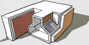 While
I was looking at Google Earth, I came across a simple 3D design
program, SketchUp, another free download from Google: www.sketchup.com
While
I was looking at Google Earth, I came across a simple 3D design
program, SketchUp, another free download from Google: www.sketchup.com
When I say simple, I mean simple to use, as it has plenty of features, I’ve been the video tutorials and after three short lessons I've got as far as this (right). I'm sure it's going to be really useful . . .