 WE'RE
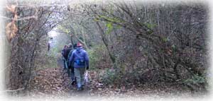
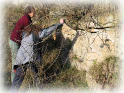
TAKING A TRIP back through time this morning, with the West Yorkshire
Geology Trust, following
the old railway cutting at Upton Colliery site in the south-east
corner of the county.
WE'RE
TAKING A TRIP back through time this morning, with the West Yorkshire
Geology Trust, following
the old railway cutting at Upton Colliery site in the south-east
corner of the county.Tracks Through Time |
Richard Bell's Wild West Yorkshire nature diary, Thursday, 15th November, 2007 |
WE'RE
TAKING A TRIP back through time this morning, with the West Yorkshire
Geology Trust, following
the old railway cutting at Upton Colliery site in the south-east
corner of the county.
Just to re-cap on the main phases in the rocky history of West Yorkshire:
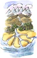
320 million years ago sand and grit was washed down from mountains to the north (and uplands elsewhere) into mighty river deltas. This became the Millstone Grit of the rugged Pennine moors and escarpments, for example, the Cow and Calf Rocks at Ilkley Moor.
 Coal
Forests
Coal
Forests300 million years ago, the greatest tropical forest the world had ever known grew on the banks of the rivers, which now deposited sand, rather than grit. The peaty remains of the forests became coal. In calmer water, silt and mud was laid down in huge quantities to form layers of shale. The rocks of the Coal Measures are sometimes referred to as the Grey Measures because shale predominates.
As they were deposited so much later, Coal Measures always lie on top of the Millstone Grit. The reason that the Millstone Grit of the moor tops now looms over the Coal Measures is that the rocks layers were upfolded by earth movements to form the Pennine Anticline.
 Sandy Desert, Limestone Sea
280 million years ago, the forests were gone and Britain lay at the arid heart of the super-continent Pangaea, where red wind-blown desert sands formed dunes on the shores of a sea, the Zechstein, which stretched across the continental shelf from Yorkshire to Poland. With little run-off of sediment from the surrounding deserts, the limy mud deposited in this sea became magnesian limestone.
Another 20 million years had elapsed, so as you'd expect, Magnesian Limestone always lies on top of the Coal Measures. The Upton Colliery shaft burrowed down through the limestone to reach the seams of coal below.
 Fault
Fault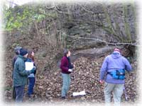 As you enter the cutting at its west end you pass a fault, where limestone
gives way abruptly to Coal Measures shale, which has weathered and is now entirely
covered with vegetation.
As you enter the cutting at its west end you pass a fault, where limestone
gives way abruptly to Coal Measures shale, which has weathered and is now entirely
covered with vegetation.
Which side of the fault was uplifted during the earth movements that caused the fault?
If you've understood my summary above, you'll realise that it was the shale, because the Coal Measures normally lie below the limestone.
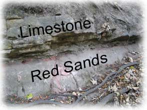
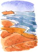
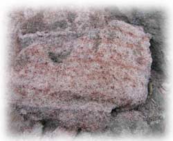 Red Sands
Close to the fault (above, right) beds of limestone project above a more easily eroded bed of red sand (which has a grey crust over it). Was this once a beach at the edge of a desert landscape, as in my sketch (above, left)?
I have a romantic view of the Zechstein Sea, which stretched from this long lost beach in tropical Upton to Poland and I generally describe it as a dying sea, to conjure up images of the Dead Sea. In fact at this early stage in its formation it wasn't dying - it lasted for millions of years. Later it went through a series of cycles of drying up and reforming, laying down substantial deposits of halite and other salts at Boulby in North Yorkshire.
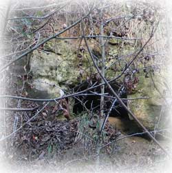 Mounds
and Hollows
Mounds
and HollowsThere are solution hollows in the rockface (left); places where the limestone has been dissolved away by water - slightly acidic water - making its way through the joints and bedding planes in the rock.
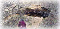 One
hollow (right), is topped by gently arching layers
of limestone. Features like this sometimes formed on the seabed when sediment
built up around colonies of single-celled blue-green algae and bacteria. I
always think of these as
algal reefs but the correct term for them is the more prosaic mud
mound.
One
hollow (right), is topped by gently arching layers
of limestone. Features like this sometimes formed on the seabed when sediment
built up around colonies of single-celled blue-green algae and bacteria. I
always think of these as
algal reefs but the correct term for them is the more prosaic mud
mound.
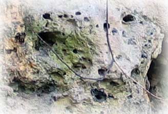 Geodes
The more you look at the rock faces in the cutting, the more features you see. What at first sight looks like uniform blocky layers of rock, reveals intriguing features that give hints to the origin and lithification of these limy sediments.
Here (right), below the roots of of a Tolkienesque old sycamore that grows out from the rockface, there are cavities known as geodes, some of which contain crystals of calcite.
West Yorkshire Geology Trust, in collaboration with Wakefield Countryside Service are planning an excursion to Upton. Date to be announced so please check out our website for details.