previous | home page | this month| e-
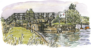
Thornes Flood Lock
Richard Bell’s Wild West Yorkshire nature diary, Tuesday, 2nd December 2008
previous | home page | this month| e-

WHEN THIS STRETCH of the River Calder was opened up to navigation there was a stipulation from the landowner that barges should sail along this stretch of the river, rather than be towed by horses. This must have added a serene element to the prospect from Lupset Hall, provided, of course, they were far enough away not to hear the grumbling and occasional curses of the bargees.
When barges reached the end of their working life they were incorporated into the sandy banks of the river to strengthen them. Archivist John Goodchild tells me that you can occasionally see their remains exposed.
The channel on the left was cut to allow barges to bypass a meander, leaving a tadpole-
On the opposite bank of the river, not far downstream, stood Ferryboat Farm. This was demolished when flood prevention plans in the valley were revised in recent years. A new levee allows the flooding of a stretch of land which has been earmarked for development as a 100 acre wetland nature reserve. Early signs are that wildfowl will flock to it.