Nature Diary Rocks History Gallery Links Home Page 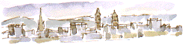 NEWTON HILL; from here, to the north of the city, you get a true picture of Wakefield in the context of the landscape from which it grew. The Cathedral tower dates from the 15th century, St Johns Church 1791, while County Hall and the Town Hall are late nineteenth century. The city slopes down towards the River Calder. On the horizon are the tops of the Pennine moors.
If you're looking for a historical figure behind the Robin Hood legend, this would be a good place to start. If you imagine the early ballad The Jolly Pinder of Wakefield as having some basis in truth then you could now be looking at the view that Robin and his outlaw companions saw when approaching Wakefield by one of the quieter routes from the forest of Barnsdale. The 14th century Robert Hode or Hood, and his wife Matilda had a house on Bichill Wakefield, which he lost when he was declared an outlaw. Robin was son of Adam Hood, of the nearby village of Stanley, forester to the Earl de Warenne.
The local hospital, built on or near the site where the Pinder impounded stray cattle is still known as Pinderfields. If you want to take a look at this timeless scene try and get here fairly soon. Last week planning permission was granted for 600 houses on the site.
A short but muddy walk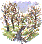 From here you can find a circular walk going from the top of Ouchthorpe Lane behind houses and the British Oak public house, across the fields towards Stanley, crossing the golf course, then turning sharp left along a footpath towards Ouchthorpe Farm, near Outwood. Turn left along the lane for a short while, cross over take the footpath on right by the pipeline enclosure to follow a footpath up a tree and thorn-lined gulley back to Newton Hill.
The Leeds Road and the Stanley Road radiating from Wakefield are familiar routes, but this small hidden patch of countryside in between is surprising. It is so close to our everyday suburban world but has kept a wild mysterious character of its own. You could almost imagine that you're treading in Robin Hood's footsteps . . .
|
 You've got to imagine open fields (as shown on the surviving Tithe and Inclosure maps) stretching from here to the city. George-a'-Green, another larger than life figure, almost as famous as Robin locally, is supposed to held the office of Pinder at the time. He was the man with the job of keeping cattle, and people, out of the communal cornfield. George was resting in the shade of a thorn tree when the outlaws came by, making there way through the corn. The ballad celebrates the ensuing sword fight, after which Robin invites the Pinder to join his outlaw band amid general feasting.
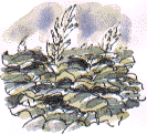 You'll see the newly restored Hatfeild Hall (clubhouse for the new golf course), a couple of tiny spoil tips and a rhubarb field. The paths can be muddy. By the golf course you walk along the end of the curiously named Finkin Lane.